
Notwithstanding the title of this review a primary focus of this walk is the Murrumbidgee River, just before it leaves the Australian Capital Territory (ACT) on its long path to Balranald where it joins with the Murray River. This in turn takes its waters to the Indian Ocean, south of Adelaide, in South Australia.
The Murrumbidgee begins its 1600 kms journey to Balranald in the alpine climes of Kosciuszko National Park, about 150 kms to the south west of Canberra. Sixty-six kilometres of its length traverses the ACT. The river as part of the Murray-Darling Basin system is one of Australia’s most important water sources for people, agriculture and wildlife, in addition to being an important recreational asset for those who visit or live along its length.

Within the ACT there are numerous walking and other recreational opportunities along its length (the ‘Murrumbidgee River Corridor’) though, alas, it is not possible to walk its full 66 kms length – at least not using marked pathways or tracks. Over a number of reviews I plan to document the walks along or close to the river which are currently marked – starting with this one in the vicinity of Uriarra and working southwards (upstream) to Angle Crossing, as depicted on the map alongside.
Returning to the title of this review I should mention how the Molonglo River fits into things. The Molonglo River, little more than a bubbling creek, flowed (and technically still flows) through Canberra, passing between Parliament House (actually both the Old and New one) and the city centre. In 1963-4 the creek was dammed to create Lake Burley Griffin which today is the centerpiece of the city. In reference to this walk, the Molonglo flows into the Murrumbidgee close to Uriarra and must be crossed by anyone seeking to continue walking along the south side of the ‘Bidgee’, as it is often referred to in Australia.
The walk, via the Molonglo River Track, to the river crossing is about 4.2 kms return with the section to and from Shepherd’s lookout being a very easy 1.2 kms of this.

Many people choose to just do this section to the Shepherd’s Lookout. The remaining 3 kilometres is rather more strenuous (at least on the return trip) being straight down to the Molonglo River. Most people who do this section, on reaching the river, continue on and do another circular walk – the Uriarra Loop (3.5 kms) – before returning to the Shepherd’s Lookout car-parking area. Walking down to the river, in addition to affording wonderful views of the Murrumbidgee and beyond from a high vantage point saves you a 28 kms circuitous drive to Uriarra Crossing – should you want to do the Loop Walk from there.
Leaving the car parking area on Stockdill Drive (about half an hours drive from Canberra city centre) it is a straight line walk to Shepherd’s lookout on a well formed path which is sealed for about half the way and compressed gravel for the remainder. While there are a couple of markers you could not possibly get lost. Additionally, metal railing at the lookout will prevent you walking of the cliff edge and tumbling down towards the distant river!

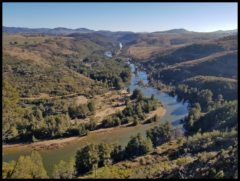
The short walk to the Lookout though Australian bush, with some introduced Black Cypress Pine Callitris endlicheri, is pleasant enough though far from spectacular. What turns the walk into spectacular and indeed one of the Canberra’s best (extremely high on my reward for effort scale) is the bird’s eye view down to the Murrumbidgee River and beyond from Shepherd’s Lookout – main picture above and imediately below.
")
")
In the distance, downstream along the river at about 3 kms (near the uppermost section of water in the photos above but not really apparent in the photos) you will see some power lines spanning the river. This unsavoury, though reasonably unnoticeable, line marks the border between the Australian Capital Territory and New South Wales. Closer in, on the northern bank of the river, at the very distinctive bend, the exposed gravel area is the remains of a sand mining venture which operated here until the early 1980s. Behind that you will notice a fire-trail (another walk). This passes though the former Retalick rural lease, one of the earliest European farms in the area. Prior to the arrival of Europeans local Aboriginals – the Ngunnawal people – lived in this area for thousands of years, as evidenced by the hundreds of stone tools found in the locality. In addition to water the river provided the Aboriginals and early European settlers with food – fish (including the now endangered Macquarie Perch and Murray Cod), yabbies and water fowl.
While sheep were almost certainly reared in this area post the arrival of European settlers in the 1820s the lookout is actually named after the Shepherd family which resided locally, as opposed to after a group of random shepherds who came here to admire the view on their day off.
Having taken in the view from the lookout it is decision time.

In the event that you do not want to go down to the Molonglo then I suggest you still veer right when leaving the Lookout and take a slightly longer (a couple of hundred metres maybe) route back to the parking area. As you do so you will get nice views westwards across some young Black Cypress Pines to the Brindabella mountain range while you traverse a less fashioned though still easy path.


Again, should you only being visiting Shepherd’s Lookout dogs, on leads, are permitted along the pathways and somewhat oddly, given the general aversion in Australia to letting dogs anywhere near where there may be wildlife, there is an area of bush next to the path (shaded on map above) where dogs (and presumably their owners) are permitted to frolic unrestricted by a lead.
If you choose to walk down to the Molonglo River again head right from the Lookout and within about 50 metres, on your right, you will see a sign directing you towards the Uriarra Picnic area. Follow this, ignoring the distance unless of course you want to extend your walk further beyond the Molonglo River, which I suggest you do.
Passing the sign, almost immediately you will enter into a grove of relatively young Black Cypress Pines growing in the thin rocky soil and descend quite steeply via about 120 steps until you come out onto a more exposed ridge.
While descending through the pine trees (in autumn/winter), and without tumbling down the side of the hill, keep your eyes on the pine trees and you may be lucky enough to spot some red headed Gang Gang Cockatoos which like to munch on the tough woody pine cones.
")
")
The young pines in this area replace trees which were lost to the devastating bushfires which raged through here and other areas of the Australian Capital Territory in January 2003.
While crossing the more open ridge you will have more great views down onto the Murrumbidgee River and across the undulating hills to the Brindabella Mountains.


Not far along the ridge you will notice a wire security fence off to your left and shorty thereafter you will follow it for a bit. Prior to seeing the rather fancifully named Lower Molonglo Water Control Centre (more commonly referred to as a sewage treatment plant) located behind this fence you will invariably smell it. While the look of the sprawling ‘water control centre’ is a greater blight on the landscape than the smell the latter does still offend one’s nose a little, even on cold winter mornings like the one I passed by. Apart from the fence-line and the dam (presumably used to release treated water into the river) depicted below I didn’t feel the urge to take pictures of the sprawling plant. Do as I did, avert your eyes to your right (descending) and concentrate on the views as you pass by.
")
")
As you leave the ‘water control centre’ behind you will encounter another 120 or so steps which take you almost down to the valley floor.

From the bottom of this bank of steps the track to the riverbank more sandy as it widens and levels out – a nice contract to the steep, narrow and, at times, rocky path down from the Lookout.

On reaching the Molonglo River it was time for morning tea so I sat down and enjoyed some snacks which I had brought with me for the occasion. This is a lovely spot to linger and enjoy the gurgling river which is traversed by a rather rustic looking footbridge affording picturesque views up and down the river.


By way of special treat, as I enjoyed my snacks a rather striking pelican glided by so quietly that I almost missed it.

If you are returning to Shepherd’s Lookout from the crossing repeat the above in reverse – remembering to avert your eyes to the left this time as you pass by the ‘water control centre’! If you are continuing on, cross the river and you will find yourself on the Uriarra Loop walk the details of which can be found in a separate review. Be aware that if there has been recent heavy rain the river may be impassable at this point.
While the walk to the Molonglo River could be completed in less than two hours, being in no hurry it took me around three. The return walk just to Shepherd’s Lookout can easily be completed, with ample viewing time, in thirty minutes. There are no toilet or other facilities anywhere along these walks and they are not served by public transport, unless you are up for a few kilometres extra hike, each way, from Holt, the closest Canberra suburb.
I will finish this review with a couple of photographs I took from Shepherd’s Lookout on a foggy morning a couple of days after I completed the full walk. Rather different but no less beautiful. I hope you agree.


For my next CANBERRA – BELCONNEN review click HERE.
For other Canberra reviews click HERE.

It’s just the kind of walk we’d love to do. 🙂 Beautiful pictures of your trail and a detailed description for those who’d like to try it out. I especially loved the picture from the elevation. Thank you for taking me along.
LikeLiked by 1 person
Thank you for joining me I am glad you enjoyed.
LikeLiked by 1 person
Amazing views! Lovely the moody, foggy impressions.
LikeLike
It looks like a beautiful walk, though maybe a bit confusing for people not familiar with it. It was a good thing about the metal railing at the lookout to prevent one from walking of the cliff edge and tumbling down towards the distant river! I loved the silently gliding pelican too. Thanks for sharing, Albert. 🙂
LikeLiked by 1 person
Thank you for reading Cathy .. it is actually a very easy walk to navigate. I think I may have made it seem overly complicated by trying to write it as two walks joined up knowing that the majority of people just visit the Lookout.
LikeLike
That’s good to know. I hope I’ll make it one day to that part of the world. 🙂
LikeLiked by 1 person
Love the views, in both sunshine and fog 🙂
LikeLiked by 1 person
I like fog scenes too – we get quite a bit here but I am always disappointed with my fog photos .. I can’t seem to capture it as I see it.. any hints?
LikeLike
I’d suggest over-exposing a tad to create a brighter look to the images – either in camera or in post-processing (or both!)
Incidentally, although I now get email alerts again when you publish a new entry, and when you like one of my comments, I don’t get one if you reply to a comment. I’ve learned now to check whenever you like one, in case you’ve also commented, but if I’ve missed any replies which, like this one, posed a question, please jog me 😉
LikeLiked by 1 person
Thanks for that Sarah… will keep trying. Aghhhh the frustrations of blogging – I’ll follow up as you suggest if I pose a question or otherwise anticipate a reply.
LikeLike
Thank you Jo. Much appreciated.
LikeLike
The river views are beautiful, aren’t they? Such a feeling of vastness in your country! 🙂 🙂 Thanks for sharing!
LikeLiked by 1 person
Thank you for reading!
LikeLiked by 1 person
Great views – especially the header photo. I know what you mean about the fog – it’s beautiful in a different way, but I would still prefer to walk without it!
LikeLiked by 1 person
A very informative blog for anyone considering walking the same route Albert – and some great pictures too.
I noticed the areas on the map where dogs could be let off their leads, which i think is a much better idea than than the other way round.
LikeLiked by 1 person
Thanks Malc… I agree with you re the map.
LikeLiked by 1 person
I remember reading about that big fire in 2003.
LikeLiked by 1 person
Thanks for reading Don.
LikeLike